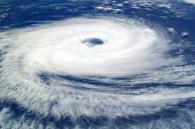
By Monday morning, Cyclone Montha had strengthened over the Bay of Bengal and was gradually approaching the coast of Andhra Pradesh. On October 28, the system is predicted to make landfall close to Kakinada.
The cyclone, which is currently centred roughly 850 km southeast of Gopalpur in Odisha and 680 km southeast of Kakinada in Andhra Pradesh, formed late Saturday night over the central Bay of Bengal, according to the India Meteorological Department (IMD). It is travelling west-northwest at a speed of about 16 km per hour.
Before making landfall, the cyclone will intensify much more.
The system is expected to develop into a strong cyclonic storm, according to the weather service, with landfall between Machilipatnam and Kalingapatnam, near Kakinada, expected to start by Tuesday evening and be finished by late night.
The forecast further stated that the cyclone is predicted to produce maximum sustained wind speeds of 90 to 100 kmph with gusts as high as 110 kmph throughout the impact process.
Images from Kakinada demonstrated the cyclone's early affects, with reports of choppy seas, swollen waves, and sporadic rain on Sunday night. The IMD issued a warning of extremely hazardous sea conditions over north coastal Andhra Pradesh and neighbouring south coastal Odisha, stating that wind speeds are expected to increase starting Monday.
Over coastal Odisha and Andhra, heavy rain is expected.
According to the most recent IMD forecast, starting late Monday evening, moderate to heavy rainfall is anticipated over a number of south Odisha districts, extending to north coastal Andhra Pradesh.
Administration On High Alert
District administrations across Ganjam, Gajapati, Rayagada, and Koraput have been instructed to activate control rooms, ensure pre-positioning of rescue teams, and stock emergency relief materials. The Odisha Disaster Rapid Action Force (ODRAF), National Disaster Response Force (NDRF), and local fire service units have been placed on standby for immediate deployment in affected areas.
During the landfall phase, persistent heavy rainfall and storm surge are likely to cause localised flooding and waterlogging in low-lying and urban areas.
By Tuesday, as the system weakens over land, the intensity of the rainfall will progressively increase over districts in the interior of Odisha.
In order to guarantee the provision of food, drinking water, and medical assistance, authorities have also prepared makeshift shelters and cyclone centres. To provide real-time information and efficient response planning, there is constant cooperation with the Indian Coast Guard, East Coast Railway (ECoR), and the IMD.

.jpg)

.jpg)

.jpg)